
Sand Blue Flag town Excellent water Protected areaFor families
Punta Bufaloria
Carovigno (BR)· Sea: Adriatic
The beach at a glance
Sandy beach with dunes and scrub in zone C of the Torre Guaceto reserve, largely free, with low rocks.
- Type of coast
- Sand
- Sand 968 m
- Rocks 741 m
- Length
- 1,709 m
- Seafront
- 79% free
- 1,357 m free352 m leased to beach clubs
- Water quality
- Excellent · classification 2024
- Off season: latest samples of the 2026 season
- ARPA bathing areas:
- PUNTA BUFALORIAExcellentMon 13 Jul: within limits
- PUNTA BUFALORIA SPIAGGIA AEREONAUTICAExcellentMon 13 Jul: within limits
- Blue Flag town
- Carovigno has the Blue Flag this year
- Protected area
- Riserva naturale marina Torre Guaceto
- Riserva naturale marina, zone C
- Riserva naturale statale Torre Guaceto
- Natura 2000 network
- ZSC Torre Guaceto e Macchia S. Giovanni (IT9140005)
- ZPS Torre Guaceto (IT9140008)
- Coastal erosion
- medium
About the beach
Punta Bufaloria is a stretch of the Carovigno coast over one and a half kilometres long, where sandy beaches backed by dunes and Mediterranean scrub alternate with low rocks. Two thirds of the beachfront are free; there is only one beach club.
This is zone C of the Torre Guaceto marine reserve: a little further south is Punta Penna Grossa, the northern tip of the protected area, with dunes, junipers and small freshwater wetlands. To the north, inland, are the towers of Morgicchio and De li Frascinari, linked to old masserie. It is part of the Torre Guaceto e Macchia S. Giovanni and Torre Guaceto Natura 2000 sites.
The seabed is sandy and slopes gently, suitable for families with children; on the rocks water shoes are best. The nearest car park is about half a kilometre away, so part of the way is on foot. The dunes are fragile and the coast is subject to erosion: walk without trampling the vegetation. With north (tramontana), north-east (grecale) and east (levante) winds the sea gets rough; with south-east (scirocco), south (ostro), south-west (libeccio), west (ponente) and north-west (maestrale) winds the beach is sheltered.
On the map
Stretch of beachBeach club
Beach clubs
On this stretch of beach or less than 300 m away.
PortoGuaceto Agribeach
Events nearby
In the coming days within 5 km.
No events within 5 km in the coming days.
Things to see nearby
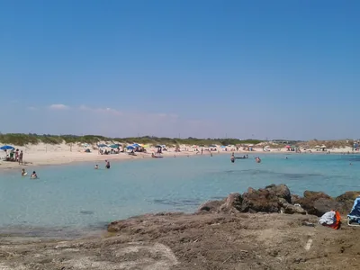 Sea and cavesPunta Penna GrossaThe long sandy beach of Punta Penna Grossa stretches in the North part of
the Nature Reserve of Torre Guaceto, amid dunes, junipers and freshwater
marsh. Carovigno very close
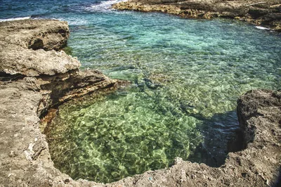 Sea and cavesTorre GuacetoA natural paradise, made of sandy coves, clear water and expanses of
Posidonia Oceanica, Torre Guaceto welcomes visitors in the shade of an
Aragonese watchtower, for a relaxing and sport holiday. Carovigno 2.1 km away
- Castles, towers and palacesTorre MorgicchioTorre Morgicchio, located inside the marina of Carovigno, stands between Torre Santa sabina and villaggio Specchiolla. Carovigno 3.5 km away
Beaches nearby
- SandPunta Penna GrossaLong beach of fine sand among dunes and junipers at the start of the Torre Guaceto reserve, almost entirely free.Free · 1 beach club Excellent water Blue Flag town Protected area Carovigno · Adriatic 1 km away
- SandTorre GuacetoBay below the tower of Guaceto and a free beach as far as the Canale Reale, in the heart of the marine protected area.Free Excellent water Blue Flag town Protected area Carovigno, Brindisi · Adriatic 2 km away
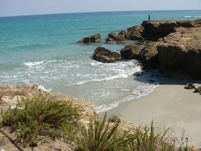 Rocks and cliffsSpecchiollaLow rocky coast with small coves in front of the village of Specchiolla, with several beach clubs and free stretches on the rocks.4 beach clubs Excellent water Blue Flag town Carovigno · Adriatic 2.7 km away
- SandPantanagianniSandy beach among dunes and scrub, largely free, with low rocks as far as the small cove of Torre Morgicchio.Free · 1 beach club Excellent water Blue Flag town Carovigno · Adriatic 4.4 km away
Sources and licences
The data comes from public sources; before swimming check the signs and the town’s bathing ordinances.
- ARPA Puglia – Monitoraggio delle acque di balneazione (CC BY 4.0)
- Regione Puglia – Aree di balneazione e classificazione 2024 (CC BY 4.0)
- Regione Puglia – Piano Regionale delle Coste (SIT Puglia) (CC BY 4.0)
- © OpenStreetMap contributors (ODbL 1.0)
- Regione Puglia – Ricognizione dei Piani comunali delle coste (A.D. 142/2025, SIT Puglia) (CC BY 4.0)
- Regione Puglia – Parchi e riserve naturali (rev. 11/2022) (CC BY 4.0)
- Regione Puglia – Perimetrazione dei siti Natura 2000 (12/2023) (CC BY 4.0)
- FEE Italia – Bandiera Blu 2026 (dato pubblico (elenco dei comuni premiati))
- Wind forecast: MET Norway (CC BY 4.0).
- Data updated: Sunday, 25 October 2026.